[ Main ] Educator's Guide
Outreach Initiatives
[ Site Map ]
Geology | Lehigh River Watershed Explorations | Weather | Environmental Issues | Data Collection Activities
 
The San Andreas Fault
The information on this page is courtesy of USGS

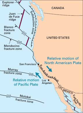
What Kind of Movement Has Occurred Along the Fault?

Blocks on opposite sides of the San Andreas fault move horizontally. If a person stood on one side of the fault and looked across it, the block on the opposite side would appear to have moved to the right. Geologists refer to this type fault displacement as right-lateral strike-slip.During the 1906 earthquake in the San Francisco region, roads, fences, and rows of trees and bushes that crossed the fault were offset several yards, and the road across the head of Tomales Bay was offset almost 21 feet, the maximum offset recorded. In each case, the ground west of the fault moved relatively northward.

Sudden offset that initiates a great earthquake occurs on only one section of the fault at a time. Total offset accumulates through time in an uneven fashion, primarily by movement on first one, and then another section of the fault. The sections that produce great earthquakes remain "locked" and quiet over a hundred or more years while strain builds up; then, in great lurches, the strain is released, producing great earthquakes. Other stretches of the fault, however, apparently accommodate movement more by constant creep than by sudden offsets that generate great earthquakes. In historical times, these creeping sections have not generated earthquakes of the magnitude seen on the "locked" sections.


Geologists believe that the total accumulated displacement from earthquakes and creep is at least 350 miles along the San Andreas fault since it came into being about 15-20 million years ago. Studies of a segment of the fault between Tejon Pass and the Salton Sea revealed geologically similar terranes on opposite sides of the fault now separated by 150 miles, and some crustal blocks may have moved through more than 20 degrees of latitude.

Although it is difficult to imagine this great amount of shifting of the Earth's crust, the rate represented by these ancient offsets is consistent with the rate measured in historical time. Surveying shows a drift at the rate of as much as 2 inches per year.


Geologic Time Scale | What is Geology? | Exploringthe Lehigh Valley | Rock on! Educational Material

Pennsylvania Geology | Which Way is North? | Geologic Explorations | Dino Inquiry | Wonderful World of Rocks and Minerals


LEO EnviroSci Inquiry is brought to you by the Lehigh Environmental Initiative at Lehigh University.
Copyright ©2000-2011 Lehigh Environmental Initiative at Lehigh University. All rights reserved.