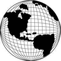
 Latitude
and Longitude are measurements used to identify and locate specific
places on earth. Every location on the globe has a unique latitude and
longitude. Latitude is defined as the
distance of a point north or south of the equator. Lines of latitude
are parallel to the equator and are often referred to as parallels.
Longitude is defined as the distance
of a point east or west of the Prime Meridian. Lines of latitude are
often called meridians.
Latitude
and Longitude are measurements used to identify and locate specific
places on earth. Every location on the globe has a unique latitude and
longitude. Latitude is defined as the
distance of a point north or south of the equator. Lines of latitude
are parallel to the equator and are often referred to as parallels.
Longitude is defined as the distance
of a point east or west of the Prime Meridian. Lines of latitude are
often called meridians.
A line to the east of the Prime Meridian has a positive
value and a line to the west has a negative value. Think of it as a
scale with the zero value in the middle. The same thing applies to latitude.
Any line north of the equator is a positive value and any line south
is a negative value.
Both latitude and longitude lines are measured in
degrees, minutes and seconds. But these are not the minutes and seconds
we know as time. Think of minutes and second simply as units of measurement.
There are 60 minutes in 1 degree, and 60 seconds in 1 minute. The measurements
in minutes and seconds are used to identify the precise location of
a point on the map. For example, a latitude of 75 degrees, 35 minutes,
15 seconds (written as 75:35:15) means that we are near the 75 degree
point north of the equator (because the value is positive). Because
there are 60 minutes in 1 degree, a measurement of 35 minutes means
that we are a little more than half way between 75 and 76 degrees. Once
we find the 35 minute mark, we get even more accurate using seconds.
There are 60 seconds in minute, therefore 15 seconds is one quarter
of a minute. We can divide a minute into four equal parts and the first
of the pars will be our 15 second mark.
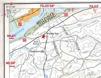
Let's try determining latitude and longitude using
the map above. If at any time you would like to see a large picture
of the map, just click on it.
Lets find the latitude and longitude of the red star. Along the edge
of the map there are measurements of latitude and longitude. They were
derived from the measurements at the top left corner. Remember, latitude
always measures east to west and longitude always measures north to
south.
The latitude of the red star is 40
degrees, 51 minutes. We determine this by lining the star up
with the closest latitude measurement. In this case the star lines up
directly with 40 degrees, 51 minutes. The longitude of the red star
is measured at the midpoint between 75 degrees, 35 minutes and 75 degrees
36 minutes. In this case we read the longitude at 75 degrees, 35 minutes
and 30 seconds. The 30 second measurement is used because the star is
aligned at the midpoint between the two minutes and half of one minute
is 30 seconds. We could break the minute down further, if it were necessary.